Allerheiligen Waterfalls
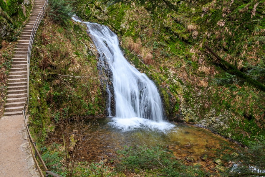
The Allerheiligen Waterfalls (Allerheiligen Wasserfälle, or All Saints Waterfalls) form a seven-cascade natural waterfall on the Lierbach stream near Oppenau, in the northern Black Forest of Baden-Württemberg. The water drops roughly 83 meters through a narrow porphyry gorge, while a stepped path with railings and bridges follows the falls.
Above the gorge stand the ruins of Allerheiligen Monastery, a Premonstratensian abbey founded in the 12th century. The two sites sit within a short walk of each other, so most visitors treat them as one outing rather than two.
A visit takes about one to two hours on foot, requires no ticket, and works best when the Lierbach carries high water after rain or spring snowmelt.
Key Takeaways
- Seven cascades carry the Lierbach about 83 meters down a narrow rock gorge near Oppenau.
- The stepped gorge path connects directly to the Allerheiligen Monastery ruins above the falls.
- Water flow, weather, and winter ice conditions change what the site looks like and whether the steps are open.
What Makes This Seven-Cascade Waterfall Significant?

These are the highest natural waterfalls in the northern Black Forest. The Lierbach formed them as it cut through hard porphyry rock in a steep, forested gorge.
The cascades sit in the mountain landscape of the Schliffkopf, Hundskopf, and Schwabenkopf, at roughly 500 meters above sea level.
How High Are the Falls and How Many Drops Do They Have?

The Lierbach descends 83 meters in total over seven separate steps. Regional tourism boards often describe the drop as “almost 90 meters,” a figure that includes the smaller cascades above and below the main sequence.
Each step has its own character. Some pour through a narrow chute between rock walls, while others spread across a wider ledge before gathering again in the pool below.
Why Are They Also Called Büttensteiner Wasserfälle and Sieben Bütten?

The falls carry the older names Büttensteiner Wasserfälle and Sieben Bütten, meaning “seven tubs.” A Bütte is a wooden tub or vat, and the word describes the round basins carved at the foot of each cascade.
Those basins are natural potholes. Stones and grit carried by the current spin at the base of each drop, grinding the rock into a bowl over long periods.
How Does the Lierbach Shape the Gorge?

The Lierbach, called the Grindenbach in its upper reaches, has cut a Schlucht (gorge) through resistant porphyry layers. Because the rock is hard, the walls stay steep and close instead of sloping back into the surrounding Waldgebiet (forest area).
This narrow, shaded corridor sits in the Renchtal, the valley that carries the Rench toward the Rhine plain. Moss, ferns, and spray-dampened stone define the gorge floor even in dry weeks.
How Do You Hike to the Falls?

The standard walk runs about one kilometer through the gorge on a built path of Treppen (staircases), railings, and short bridges. It climbs from the lower parking area at 518 meters to the monastery ruins at 630 meters.
Most visitors allow 30 to 45 minutes one way, though photo stops can easily add time.
What Is the Route Through the Gorge?

From the lower parking lot below the falls, the path passes through a large wooden portal and enters the gorge alongside the Lierbach. It then climbs beside the cascades, crossing the stream several times on footbridges.
The upper end of the waterfall sequence arrives quickly. From there, an easy graded path continues to the inn and the Allerheiligen Monastery ruins.
Walking downhill from the monastery is the gentler option. Anyone starting at the top without a second car will need to climb back up.
How Demanding Are the Stairs and Bridges?

The route is short but steep, with several hundred steps and continuous handrails. Sure footing and reasonable fitness make it manageable; strollers and wheelchairs cannot use the gorge section.
Wet stone and metal treads stay slippery long after rain. Shoes with good grip make more difference here than on most Black Forest paths, a point worth noting for anyone new to German wandern-hiking-culture/” rel=”noopener” target=”_blank”>hiking culture.
Can You Follow the Allerheiligen Circular Walk?

Yes. Circular routes start at the monastery ruins, descend the gorge, and return through mixed forest. Longer loops continue to the Schliffkopf ridge, covering roughly 12.8 kilometers in about four hours.
The Renchtalsteig long-distance trail also passes here. It crosses the Lierbach behind the ruins before climbing the western flank of the Schliffkopf.
How Is the Waterfall Linked to Allerheiligen Monastery?

The falls and the abbey share one site. Builders placed the monastery directly above the gorge in the late 12th century, and its ruins now mark the upper end of the waterfall path.
Both lie within the town of Oppenau, in the Ortenau district between Achern and the Rhine plain.
What Remains of the Former Premonstratensian Abbey?

Standing sandstone walls, Gothic window openings, and the outline of the church nave survive. Lightning destroyed the abbey church in 1804, and people later quarried its stone, leaving the roofless shell visible today.
The grounds are open and free to walk. Concerts and readings take place among the walls during the warmer months.
How Did the 1840 Path Make the Gorge Accessible?

Before 1840, visitors could reach the gorge only by narrow mule tracks, and early travelers descended using ladders. The first constructed path opened 36 years after the church burned, turning a difficult ravine into a walkable route.
Later work in the early 20th century added the stairs, railings, and bridges that define the modern climb.
Which Renchtal Legends Are Connected to the Site?

One Renchtal legend explains the abbey’s odd location: a donkey loaded with a sack of money was set loose, and builders raised the monastery where the sack fell. A marked legend trail near the ruins collects this and other local stories.
The tale reflects a practical truth. Water power and isolation both drew builders to this steep valley, much as they shaped monastic sites elsewhere across Germany’s regions.
When Should You Visit and How Do You Plan Your Trip?

Spring snowmelt and the days after heavy rain produce the strongest flow, while summer weekends bring the largest crowds to the gorge path. Oppenau lies in the Ortenau district of Baden-Württemberg, about a 45-minute drive from Baden-Baden or Offenburg.
Where Can You Park Near the Trailheads?

Two main lots serve the site. The lower lot sits at 518 meters directly below the falls on the Lierbachstraße. A second area lies on the K5370 road near the monastery ruins, which suits visitors who prefer to walk downhill.
Both fill early on summer weekends and holidays. Parking fees and seasonal closures change, so check the current signs before setting out.
When Is Water Flow Most Impressive?

March through May brings meltwater from the Grinden heights, and the cascades run hardest then. Autumn rain produces similar volume, with fewer visitors and colored beech foliage in the gorge.
Late summer can reduce the flow to thin ribbons after dry spells. Winter transforms the falls into ice formations, though the stairs are frequently closed for safety.
What Should Visitors Know About Safety and Conditions?

The gorge path closes during ice, storm damage, or repair work, and the town of Oppenau posts these closures at the trailhead. Stay on the marked steps; the wet rock beside the stream offers no reliable footing.
Pair the visit with nearby stops such as Mummelsee Lake on the Schwarzwaldhochstraße or the Triberg Waterfalls farther south. Everything About Germany keeps destination profiles that place sites like this within their regional history and customs.
Frequently Asked Questions

Where are the Allerheiligen Waterfalls located?
The Allerheiligen Waterfalls lie in the northern Schwarzwald (Black Forest), within the town limits of Oppenau in Baden-Württemberg, at about 500 meters elevation. They sit on the Lierbach stream below the Allerheiligen Monastery ruins, surrounded by the Schliffkopf, Hundskopf, and Schwabenkopf.
How do you get to the Allerheiligen Waterfalls?
Driving is the most practical option: follow the Lierbachstraße north from Oppenau, roughly 45 minutes from Offenburg or Baden-Baden. Seasonal bus service on the Schwarzwaldhochstraße reaches the monastery stop, but schedules vary by month, so confirm current timetables before traveling. Broader route ideas appear in the Germany travel guide.
Is there parking at the Allerheiligen Waterfalls?
Yes. A lot sits directly below the falls at 518 meters, and additional spaces are available near the monastery ruins on the K5370. Both lots fill quickly on summer weekends, and fees and availability change with the season.
How long is the hike at the Allerheiligen Waterfalls?
The gorge path runs about one kilometer each way and takes 30 to 45 minutes uphill, with several hundred steps. Circular routes linking the falls, the ruins, and the Schliffkopf plateau extend to roughly 12.8 kilometers and about four hours.
Are the Allerheiligen Waterfalls worth visiting after rain?
Yes. The Lierbach carries much more water after rainfall and during the spring snowmelt, so all seven cascades run full. The steps and railings can get slick, though, so allow a little extra time for the descent.
💡 Visitor Tips & Best Experience
Visit early in the morning to avoid tour groups and wear comfortable walking shoes for cobblestones.
🚆 How to Get There & Public Transit
Accessible via Deutsche Bahn regional and intercity rail networks.
🎟️ Popular Tours & Tickets for Allerheiligen Waterfalls
Compare tickets and guided experiences. Check available dates, what is included, and the provider's cancellation terms before booking.